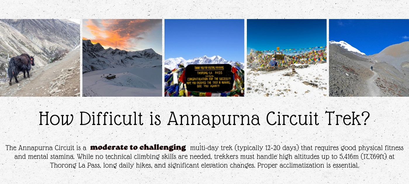
The Annapurna Circuit is a moderate to challenging high-altitude trek. It spans 160–230 km and takes 12 to 20 days. While it requires no technical climbing skills, the sheer distance, unpredictable weather, and high altitude, peaking at 5,416 m (17,769 ft) at Thorong La Pass, make it a demanding physical and mental test.
Key Difficulty Factors of Annapurna Circuit in 2026
Altitude: The primary risk is Acute Mountain Sickness (AMS), particularly above 3,000m. The ascent to Thorong La Pass is challenging.
Physical Stamina: Expect 6–8 hours of walking per day, with steep ascents and long, knee-taxing descents
Weather and Environment: Conditions are unpredictable; trekkers may face extreme cold, snow at higher altitudes, and rain
Length: The long duration demands endurance and mental stamina to deal with basic, rustic accommodation and simple food
How hard is Annapurna Circuit Trek?
The Annapurna Circuit is one of the greatest long-distance treks in the world. It circles the entire Annapurna massif in Nepal's central Himalayas, taking you through subtropical lowlands, pine forests, high-altitude deserts, and over Thorong La Pass at 5,416 meters. The route covers 160 to 230 kilometers and passes through some of the most culturally and geographically diverse landscapes on Earth.
You've read the blog posts. You've watched the YouTube videos. And somewhere between the prayer flag photos and the summit selfies, a very specific question has been eating at you: is this trek actually within reach, or is it going to break you at 5,000 meters with no way back?
That fear is valid. The Annapurna Circuit crosses Thorong La Pass at 5,416 meters (17,769 feet), where the air carries only 47% of the oxygen available at sea level. People do turn back. Some get evacuated. But thousands also complete it every year, including people who had never trekked at altitude before.
By the end of this guide, you will know exactly how difficult the Annapurna Circuit trek is, which sections are genuinely hard versus overhyped, what your body will go through above 4,000 meters, how beginners stack up against experienced trekkers on this route, and what separates those who summit Thorong La from those who don't.
This Annapurna Circuit Trek Difficulty guide covers:
The honest difficulty rating and what it actually means
A stage-by-stage difficulty breakdown of the full route
Altitude and AMS risk with specific elevation thresholds
Thorong La Pass: the hardest day, explained in detail
Beginner vs experienced trekker reality check
Seasonal difficulty differences for 2026
How to prepare physically and mentally
Annapurna Circuit vs Everest Base Camp difficulty comparison
Annapurna Circuit Difficulty Level: The Real Rating (4/5) in 2026
The Annapurna Circuit trek is moderate to challenging (4/6), and that range is intentional, not vague. Where you land on that spectrum depends entirely on three variables: your fitness coming in, how well your body handles altitude, and whether you follow a proper acclimatization schedule.
Here is the full difficulty profile of Annapurna Circuit Difficulty factors at a glance:
Factor
Detail
Overall Rating
Moderate to Challenging
Maximum Altitude
5,416 m / 17,769 ft (Thorong La Pass)
Total Distance
160 to 230 km depending on route and detours
Daily Walking Time
6 to 8 hours average
Total Duration
12 to 20 days
Technical Skill Required
None. No ropes, no climbing equipment
Altitude Sickness Risk
High above 3,500 m
Hardest Single Day
Thorong La Pass crossing (Day 11 to 13 depending on itinerary)
Oxygen at Summit
47% of sea level
Recommended Fitness
Good cardiovascular baseline, not elite athlete level
Permit Required
ACAP (Annapurna Conservation Area Permit) + TIMS card
What most blogs leave out: the difficulty of the Annapurna Circuit is not uniform. The first four days feel almost gentle. Days five through eight introduce real altitude. Days nine and ten hit the mental wall. Day eleven, the Thorong La crossing, is in a category of its own. Understanding this arc changes how you prepare.
Stage-by-Stage Difficulty Breakdown of Annapurna Circuit Itinerary
The Annapurna Circuit doesn't grind you down steadily. It builds in waves. Each stage has its own character, the long, tiring distance of Annapurna Circuit its own challenge, and its own way of testing a different part of you.
Stage 1: Besisahar to Chame (Days 1 to 4): Confidence Zone of ACT
The trek begins at Besisahar at 760 meters and climbs gradually through subtropical forest, terraced farmland, and riverside trails to Chame at 2,650 meters. Daily elevation gain stays manageable. The trails are well-marked and wide in most sections.
Honest reality: this stage feels easy. Almost too easy. The danger here isn't the trail, it's the pace. Trekkers who feel strong in this section tend to push harder than they should, setting themselves up for AMS trouble later. The golden rule starts here: slow is fast on the Annapurna Circuit.
Stage 2: Chame to Manang (Days 5 to 7): Reality Check Zone of Annapurna
The trail climbs from Chame through Upper Pisang at 3,300 meters and up to Manang at 3,540 meters. The air starts to thin noticeably. Morning headaches begin. Appetite drops slightly. Some trekkers notice they need an extra breath when tying their boots.
This is where the Annapurna Conservation Area really opens up. The views of Annapurna II (7,937 m), Annapurna III (7,555 m), and Gangapurna (7,455 m) become dominant. The trail switches between pine forest ridges, wide glacial valleys, and exposed plateau sections.
What most guides won't tell you: the section from Lower Pisang to Upper Pisang involves a significant ridge climb that adds roughly 200 meters of elevation gain compared to the valley route. Most trekkers take the lower road for speed. But the upper route through Ghyaru and Ngawal delivers substantially better mountain views and better acclimatization gain for the same time investment.
Stage 3: Manang Acclimatization Day: The Day That Decides Everything
Manang at 3,540 meters is where every serious trekker builds in a mandatory rest day. This isn't optional. The Wilderness Medical Society guidelines, referenced by Nepal's own trekking associations, recommend no more than 300 to 500 meters of net altitude gain per day above 3,000 meters, with a rest day every third day of ascent.
Skipping the Manang acclimatization day is the single most common reason trekkers fail to cross Thorong La Pass. That is not an exaggeration. During the acclimatization day, the standard recommendation is to hike up to Ice Lake at 4,620 meters or Gangapurna Viewpoint at approximately 3,900 meters and return to sleep at Manang. The physical act of climbing higher and sleeping lower triggers red blood cell production and accelerates your body's adaptation to reduced oxygen.
Stage 4: Manang to Thorong Phedi (Days 8 to 10): Mental Wall Zone
The trail climbs from Manang through Yak Kharka at 4,018 meters and up to Thorong Phedi at 4,450 meters, with the option of pushing to High Camp at 4,800 meters. This is where the altitude becomes a constant presence rather than an occasional reminder.
Daily distances shrink but effort levels spike. A 10-kilometer day at 4,200 meters burns significantly more energy than a 15-kilometer day at 2,000 meters. Sleep quality deteriorates. Most trekkers notice the Cheyne-Stokes breathing pattern at night, a periodic stopping and starting of breath during sleep that is a normal physiological response to altitude but deeply unsettling the first time you experience it.
The trail between Yak Kharka and Thorong Phedi is exposed, dry, and wind-scoured. There is very little shelter. Temperatures drop sharply after 2 PM. Most experienced guides recommend arriving at Thorong Phedi or High Camp by early afternoon and resting completely for the remainder of the day before the early start.
Stage 5: Thorong La Pass Crossing (Day 11 to 13): Hardest Part of Annapurna Circuit Trek
This is covered in its own dedicated section below. It is the hardest day of the trek by a significant margin.
Stage 6: Muktinath to Jomsom (Days 12 to 14): Relief Run
After descending from Thorong La Pass to Muktinath at 3,800 meters, the psychological weight lifts. The hardest challenge is behind you. But the physical work isn't finished. The descent from the pass to Muktinath drops 1,616 meters in approximately 8 kilometers, which is brutal on the knees and ankles.
The trail continues through Kagbeni at 2,800 meters and down to Jomsom at 2,720 meters, the usual endpoint for most trekkers who fly back to Pokhara from Jomsom airport. The Mustang landscape here is striking, a near-barren high-altitude desert carved by the Kali Gandaki river gorge, the deepest gorge in the world.
Altitude Is the Real Challenge, Not the Distance
This is the most important thing to understand about the Annapurna Circuit trek difficulty. Most trekkers prepare for the kilometers. The mountain tests them with the altitude.
Above 3,000 meters, the human body begins working harder to extract oxygen from each breath. Above 3,500 meters, AMS (Acute Mountain Sickness) risk becomes clinically significant. Above 4,500 meters, even fit, acclimatized trekkers notice measurable performance decline. At 5,416 meters, the summit of Thorong La Pass, your lungs are processing air with roughly half the oxygen density of what you breathe at sea level.
AMS is not a fitness issue. Elite athletes get altitude sickness. Sedentary travelers sometimes acclimatize with no symptoms at all. The physiological response to altitude is largely genetic and unpredictable, which makes proper acclimatization protocol non-negotiable regardless of how fit you are.
Understanding AMS, HACE, and HAPE: The Three Altitude Risks
AMS (Acute Mountain Sickness) is the most common condition. Symptoms include a persistent headache that worsens when lying flat, nausea, loss of appetite, fatigue disproportionate to effort, and disrupted sleep. AMS typically appears within 6 to 12 hours of arriving at a new altitude. Mild AMS can be managed with rest, hydration, and by not ascending further until symptoms resolve completely.
HACE (High Altitude Cerebral Edema) is a severe progression of AMS where fluid builds around the brain. Symptoms include severe headache unresponsive to paracetamol, loss of coordination (ataxia), confusion, and altered consciousness. HACE is a medical emergency. Immediate descent of at least 500 to 1,000 meters is the primary treatment. Dexamethasone can be administered as a bridge to descent.
HAPE (High Altitude Pulmonary Edema) is fluid accumulation in the lungs. Symptoms include breathlessness at rest, a persistent cough that may produce pink frothy sputum, extreme fatigue, and a feeling of drowning. HAPE is the leading cause of altitude-related death in trekkers and can develop rapidly. Immediate descent and supplemental oxygen are critical.
The Himalayan Rescue Association (HRA) operates an aid post in Manang that provides altitude sickness screenings, SpO2 (blood oxygen saturation) testing, and trekker briefings. A normal SpO2 reading at Manang altitude is approximately 85 to 90%. Below 80% with symptoms warrants serious attention. Below 75% is a medical alert regardless of how you feel.
Disclaimer:
This information is educational. Consult a travel medicine physician before departure. AMS symptoms overlap with dehydration and fatigue. Self-diagnosis at altitude is unreliable. Always defer to your guide's judgment and HRA medical staff.
Altitude Difficulty by Elevation Zone of Annapurna
Elevation Zone
Location on Trek
Oxygen Level
AMS Risk
Below 2,500 m
Besisahar to Bagarchap
74 to 100%
Low
2,500 to 3,500 m
Chame to Manang
65 to 74%
Moderate
3,500 to 4,500 m
Manang to Thorong Phedi
58 to 65%
High
4,500 to 5,416 m
High Camp to Thorong La
47 to 58%
Very High
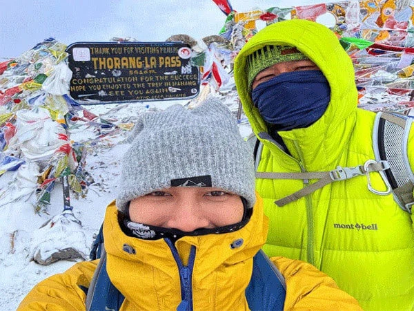
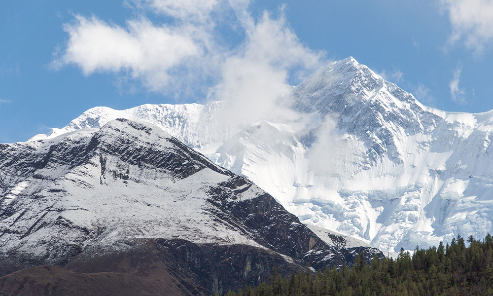
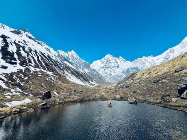
Thorong La Pass: What the Hardest Day Actually Feels Like
Highest Point of Annapurna Circuit - Thorong la pass
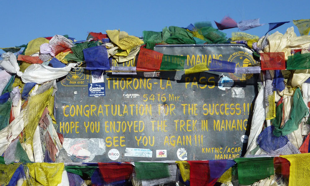
Thorong La Pass at 5,416 meters (17,769 feet) is the highest point on the Annapurna Circuit and the defining challenge of the entire trek. Understanding what this day involves, hour by hour, is essential preparation.
Most trekkers start from either Thorong Phedi (4,450 m) or High Camp (4,800 m). The standard recommendation from experienced guides, including those at Index Adventure, is to sleep at High Camp the night before the crossing and start the summit push between 3:30 AM and 4:30 AM.
Here is why the timing matters more than most guides explain: the wind pattern on Thorong La changes dramatically after approximately 9 AM to 10 AM. In spring (March to May), westerly winds that are manageable in the early morning shift to strong cross-winds by mid-morning. In autumn (September to November), afternoon wind speeds at the pass regularly exceed 60 kilometers per hour. Trekkers who start late face a significantly harder crossing and a genuine safety risk if weather deteriorates.
Hour-by-Hour Reality of the Thorong La Crossing
The first two hours from High Camp involve a steady switchback climb on a loose rocky trail in complete darkness. At this altitude, your headlamp feels insufficient. Every 20 steps, most trekkers stop to breathe. This is normal. A 5-step-pause-5-step rhythm is common and efficient.
By the third hour, you are above 5,000 meters. This is where the mental wall appears. The summit is visible but seems to refuse to get closer. Your legs feel disproportionately heavy. The cold at this elevation, typically between minus 10 and minus 20 degrees Celsius before sunrise, bites through base layers. Trekkers who underpack insulation at this stage suffer noticeably.
At approximately the fourth to fifth hour from High Camp, you reach the Thorong La Pass summit cairn and prayer flags at 5,416 meters. The view opens across the entire Annapurna massif to the south and the Mustang plateau to the north. This is genuinely one of the most striking landscapes accessible to non-technical trekkers anywhere on Earth.
The descent to Muktinath covers approximately 8 kilometers and drops 1,616 meters. It takes 3 to 4 hours. The trail is steep, rocky, and unrelenting on the knees. Trekking poles are not optional on this descent. They are protective equipment.
What Index Adventure guides recommend for Thorong La: carry at least 2 liters of water from High Camp, eat something substantial even if appetite is absent (glucose biscuits and nuts work well at altitude when hot food feels impossible), and never let more than 30 minutes pass without at least 3 to 4 sips of water. Dehydration at altitude accelerates AMS symptoms faster than almost any other factor.
Annapurna Circuit Trek Difficulty for Beginners
Beginners can complete the Annapurna Circuit trek. That is a factual statement, not a motivational one. Thousands of first-time high-altitude trekkers complete it every season. But "can complete" and "will find easy" are entirely different things.
Here is an honest beginner difficulty assessment:
The sections below 3,500 meters are manageable for any moderately active person who walks regularly and has no significant cardiovascular or respiratory conditions. The altitude sections above 3,500 meters introduce a variable that no amount of fitness preparation fully eliminates: your body's individual response to reduced oxygen.
The most common mistake beginners make on the Annapurna Circuit is not the physical preparation. It is the pace. Beginners tend to either push too hard in the early stages (burning reserves needed later) or fall behind acclimatization schedules by taking too many extra rest days in comfortable lower-altitude villages and then rushing the high sections to stay on schedule.
Beginner Risk Assessment
Factor
Beginner Reality
Mitigation
AMS risk
Higher due to no prior altitude exposure
Follow strict acclimatization schedule
Physical fatigue
Significant by Day 8 to 10
Train 8 to 12 weeks before departure
Navigation
Trail is well-marked, low risk of getting lost
Download offline maps as backup
Mental stamina
Hardest challenge for most beginners
Build mental resilience through preparation
Emergency response
Less experienced in recognizing symptoms
Guide is essential, not optional
The honest recommendation for beginners: hire a guide. Not because the trail is unmarked or technically complex, but because an experienced guide reads your physical symptoms before you do. They have seen AMS progress from mild to HACE in under 12 hours. That pattern recognition is not something a first-timer can replicate from a blog post.
Fitness Level Required for Annapurna Circuit Trek
The Annapurna Circuit does not require elite fitness. It requires sustained fitness. There is a significant difference.
Elite fitness means peak output: sprinting, lifting maximum loads, explosive power. Sustained fitness means maintaining consistent moderate effort over 6 to 8 hours daily, for 12 to 20 consecutive days, at progressively higher altitudes. The cardiovascular demand is cumulative, not acute.
Recommended Pre-Trek Training (8 to 12 Weeks Out)
Cardiovascular base: Run, cycle, or swim for 45 to 60 minutes at moderate intensity, 4 to 5 days per week. The goal is raising your aerobic threshold, not speed.
Leg strength and endurance: Weighted hiking (5 to 8 kg daypack) on inclined terrain for 2 to 3 hours, twice per week. Stair climbing with a loaded pack is a highly effective urban substitute. Single-leg exercises including lunges, step-ups, and Bulgarian split squats build the stabilizer muscles that take the punishment on long descents.
Altitude simulation: If you have access to altitude training facilities or live above 2,000 meters, incorporate high-altitude exposure into your training. If not, the most practical preparation is ensuring your cardiovascular base is strong. The body adapts faster at altitude when the aerobic system is already efficient.
Recovery capacity: Sleep quality, nutrition, and hydration habits formed before the trek carry directly into the trek. Poor recovery habits at home become dangerous habits at 4,500 meters.
A realistic self-test: Can you comfortably hike for 5 to 6 hours carrying a 6 to 8 kg pack on hilly terrain without stopping from exhaustion? If yes, you have the baseline. If no, you have 8 to 12 weeks to build it.
Annapurna Circuit vs Everest Base Camp: Which Is Harder?
This is one of the most searched comparisons in Nepal trekking research, and most answers oversimplify it. Here is the full picture.
Factor
Annapurna Circuit
Everest Base Camp
Maximum Altitude
5,416 m (Thorong La Pass)
5,364 m (Base Camp)
Total Distance
160 to 230 km
130 km (round trip)
Duration
12 to 20 days
12 to 14 days
Daily Altitude Gain
Varies, max around 800 m on pass day
More gradual, structured
Terrain Variety
Extremely diverse, subtropical to alpine desert
Primarily single valley, gradual
Technical Difficulty
No technical climbing
No technical climbing
AMS Risk
Very high at Thorong La
High at Gorak Shep and Base Camp
Pass Crossing
Yes, Thorong La at 5,416 m
No high pass crossing
Overall Physical Demand
Higher due to distance and terrain variety
Moderate to high
Mental Difficulty
Higher due to duration
Moderate
The honest verdict: the Annapurna Circuit is generally more physically demanding due to its total distance, terrain diversity, and the single-day extreme effort of the Thorong La crossing. Everest Base Camp is more straightforward in route structure but reaches a similar altitude and carries comparable AMS risk in its upper sections.
Neither trek is harder in an absolute sense. They test different things. The Annapurna Circuit tests endurance, adaptability, and sustained effort. Everest Base Camp tests altitude tolerance in a more concentrated form.
Seasonal Difficulty: When You Trek Changes Everything
The Annapurna Circuit's difficulty rating shifts significantly depending on when you go. The same trail that is manageable in October becomes genuinely dangerous in January.
Spring (March to May): Recommended
March to May is one of the two optimal windows. Daytime temperatures at Manang range from 5 to 12 degrees Celsius. Thorong La Pass is generally clear of heavy snow by late March. Rhododendron forests below 3,000 meters bloom through April, making the lower sections visually exceptional. The primary challenge is trail congestion during peak April weeks, which affects teahouse availability and adds noise to an otherwise meditative experience.
April specifically sees the highest concentration of trekkers and is also statistically the best weather window for a clear Thorong La crossing.
Autumn (September to November): Recommended
September to November is the other optimal window. Post-monsoon trails are firm, views are crystal clear, and temperatures are stable. October is the single best month on the entire circuit: cool, dry, clear, and not yet cold enough to create significant snow risk on the pass.
November introduces falling temperatures and the first serious snowfall risk at High Camp and the pass. Late November crossings require careful weather monitoring and cold-weather gear that April trekkers don't need.
Monsoon (June to August): Not Recommended for Most
Heavy rainfall makes trails slippery, leeches infest lower sections, mountain views are largely obscured, and the risk of landslides on certain trail sections is real. The Annapurna Circuit is one of Nepal's more rain-affected treks during monsoon. The upper Mustang rain shadow provides some protection above Kagbeni, but getting there through the lower sections in full monsoon is genuinely uncomfortable and carries safety risks.
Winter (December to February): For Experienced Trekkers Only
Thorong La Pass closes periodically between December and February due to heavy snowfall. Temperatures at High Camp drop to minus 20 to minus 30 degrees Celsius overnight. The trail between Yak Kharka and the pass can be completely buried. Trekkers attempting winter crossings need full mountaineering cold-weather gear, significant prior winter trekking experience, and ideally a guide with specific winter Annapurna Circuit experience.
Winter does offer one genuine advantage: the trail is nearly empty. Teahouses are open but quiet. The Himalayan silence at 4,000 meters in January is an experience of its own kind.
Season
Difficulty Rating
Key Risk
Best For
Spring (Mar to May)
Moderate
Congestion, afternoon winds
Most trekkers
Autumn (Sep to Nov)
Moderate
Late snow in November
Most trekkers
Monsoon (Jun to Aug)
High
Landslides, leeches, low visibility
Experienced only
Winter (Dec to Feb)
Very High
Pass closure, extreme cold
Expert trekkers
How to Make the Annapurna Circuit Easier
Difficulty is not fixed. The same trek can be a manageable adventure or a suffering exercise depending entirely on the choices made before and during it.
Use trekking poles. This is the single most impactful gear decision for the Annapurna Circuit. On the 1,616-meter descent from Thorong La to Muktinath, poles reduce knee impact by approximately 25%, according to biomechanical studies referenced by the American College of Sports Medicine. They also provide stability on icy early-morning sections above 4,500 meters.
Follow the acclimatization schedule without compromise. Every day saved by skipping a rest day is a day borrowed against your Thorong La attempt. The Himalayan Rescue Association's Manang aid post data consistently shows that the majority of emergency evacuations from the Annapurna Circuit involve trekkers who abbreviated their acclimatization.
Hire a porter. Walking with 6 to 8 kilograms versus 15 to 20 kilograms at altitude is not a comfort difference. It is a physiological difference. Every extra kilogram of load at 4,500 meters increases your oxygen demand and accelerates fatigue. A porter from a reputable agency like Index Adventure ensures the load is carried ethically with proper equipment, insurance, and fair wages.
Eat garlic soup in Manang. This is not folklore. Food and Drinks during Annapurna Circuit Trip play a vital role in your journey completion. Garlic contains allicin, which has vasodilatory properties that may support circulation at altitude. Whether the clinical effect is significant is debated, but the practical effect, warm, calorie-dense, easily digestible food that the local teahouses make well, is unambiguous. Order it every night from Manang onwards.
Start the Thorong La crossing no later than 4:30 AM. This single decision eliminates the wind risk, avoids afternoon weather deterioration, and gives you a full day to recover in Muktinath before the next stage.
Do You Need a Guide for the Annapurna Circuit?
Officially, yes. As of April 1, 2023, the Nepal Tourism Board requires all foreign trekkers in the Annapurna region to hire a licensed guide or porter-guide. While some independent trekkers report inconsistent enforcement, officially, you cannot obtain the required TIMS card without an authorized trekking agency.
But the question of whether you legally need a guide is different from whether you should have one.
An experienced local guide on the Annapurna Circuit provides three things that no app or guidebook replicates: real-time altitude assessment, local weather knowledge specific to the Thorong La crossing window, and emergency response capacity. The Himalayan Rescue Association notes that trekkers with guides are significantly more likely to make timely descent decisions when AMS symptoms appear.
For solo trekkers without prior high-altitude experience, the guide question should be settled before arrival in Nepal, not debated at Thorong Phedi at 4 AM with a headache. Index Adventure's licensed guides on the Annapurna Circuit carry pulse oximeters, are trained in Wilderness First Responder protocols, and have crossed Thorong La Pass an average of over 50 times each. That institutional knowledge of the pass, its weather windows, its emergency descent routes, and its medical risks is not replaceable.
The TAAN (Trekking Agencies' Association of Nepal) recommends that all first-time high-altitude trekkers in Nepal use a registered guide agency. Index Adventure is a TAAN-registered operator with guides certified through the Nepal Academy of Tourism and Hotel Management (NATHM).
Ready to plan your Annapurna Circuit trek with a team that has crossed Thorong La in every season? Index Adventure builds custom itineraries around your fitness level, experience, and available dates. Inquire today and receive a response within 24 hours.
Annapurna Circuit Trek Recent Review 2026
Just finished our Annapurna Circuit trek with Index Adventure. Trekking in the Himalayas was a dream come true for me and Index Adventure provided exceptional service. Our guide Keshav Thapa and his assistant were great and very knowledgeable about the Annapurna region.......Read more
Review By: Jennifer | Malaysia
Conclusion
The difficulty of the Annapurna Circuit trek is real, specific, and manageable with the right preparation. It is not a walk in the park. It is not beyond reach either. The trek crosses Thorong La Pass at 5,416 meters, demands 12 to 20 days of sustained effort, and tests altitude tolerance in a way that no lower-elevation trek prepares you for.
What separates those who summit from those who don't is rarely fitness. It is preparation, acclimatization discipline, pace management, and the quality of support around them on the trail.
Whether you are approaching the Annapurna Circuit as a complete beginner or as a trekker with prior Himalayan experience, the difficulty of this route rewards those who respect it. Go slow. Go prepared. Go with people who know the mountain.
Index Adventure's Annapurna Circuit packages include licensed NATHM-certified guides, full permit support, acclimatization-optimized itineraries, and 24-hour emergency communication. No guesswork. Just the Annapurna massif, one step at a time
Frequently Asked Questions about Annapurna Circuit Difficulty
Is the Annapurna Circuit trek difficult?
The Annapurna Circuit is moderate to challenging. It reaches 5,416 meters at Thorong La Pass, involves 6 to 8 hours of daily hiking over 12 to 20 days, and carries a significant risk of Acute Mountain Sickness above 3,500 meters. With proper preparation and acclimatization, most healthy adults can complete it.
How difficult is the Annapurna Circuit trek for beginners?
Beginners can complete the Annapurna Circuit with proper preparation. The primary risk for beginners is altitude sickness, not trail difficulty. An 8 to 12 week cardiovascular training program, a strict acclimatization schedule, and a licensed guide significantly reduce the risk for first-time high-altitude trekkers.
What is the hardest part of the Annapurna Circuit trek?
The hardest part is the Thorong La Pass crossing at 5,416 meters. Trekkers gain approximately 800 meters of elevation from High Camp and descend 1,616 meters to Muktinath in a single day. The crossing typically takes 7 to 9 hours total and is done starting before dawn in temperatures that can reach minus 15 degrees Celsius.
Is the Annapurna Circuit harder than Everest Base Camp?
The Annapurna Circuit is generally more physically demanding due to its greater total distance (160 to 230 km versus 130 km), more varied terrain, and the single extreme-effort day of the Thorong La Pass crossing. Everest Base Camp reaches a similar maximum altitude of 5,364 meters but follows a more gradual single-valley route without a high pass crossing.
Can a beginner climb Annapurna?
Annapurna I (8,091 m) is one of the most technically dangerous 8,000-meter peaks in the world and is not accessible to beginners. The Annapurna Circuit trek, which circumnavigates the Annapurna massif, is a separate, non-technical route accessible to well-prepared beginners. These are two entirely different activities.
Is the Annapurna Circuit dangerous?
The Annapurna Circuit carries real risks, primarily Acute Mountain Sickness, HACE, and HAPE above 3,500 meters, as well as trail hazards during monsoon season and potential pass closure in winter. These risks are manageable with proper preparation, acclimatization, and experienced guide support. The trail itself is well-established and regularly patrolled.
How many days does the Annapurna Circuit trek take?
The Annapurna Circuit takes 12 to 20 days depending on the itinerary, acclimatization days included, and whether transportation is used on road sections. A 15 to 16 day itinerary with a rest day in Manang and a High Camp night before Thorong La is the most commonly recommended schedule for a safe, complete crossing.
How much does it cost to hike the Annapurna Circuit?
The main permit costs are the ACAP (Annapurna Conservation Area Permit) at NPR 3,000 (approximately USD 22) and the TIMS card at NPR 2,000 (approximately USD 15) for individual trekkers. Total trek costs including accommodation, food, guide, porter, and flights from Jomsom to Pokhara typically range from USD 800 to USD 2,500 depending on group size, guide agency, and accommodation standards. Prices are subject to change; verify current rates with the Nepal Tourism Board before departure.
What is the Annapurna Circuit trek itinerary?
A standard 14-day Annapurna Circuit itinerary begins in Besisahar (760 m), progresses through Chame (2,650 m), Upper Pisang (3,300 m), and Manang (3,540 m) with a rest day, continues through Yak Kharka (4,018 m) and Thorong Phedi or High Camp (4,450 to 4,800 m), crosses Thorong La Pass (5,416 m) to Muktinath (3,800 m), and descends through Kagbeni (2,800 m) to Jomsom (2,720 m) for the flight to Pokhara.